Image of a wooden Amazonian village beneath the mountains.

Amazons, Part II: Amazonia

This is Part II of a four-part series (I, III, IVa, IVb) on the Amazons. In Part I, we looked at what ancient scholars had to say about the origins, society, and history of this legendary female tribe. Today, we will examine the geography of their homeland in northern Anatolia, which I will refer to as Amazonia.

Understanding the geography of Amazonia allows us to analyze the history of this region, which we will do in Part III. This brings us one step closer to proving that the Amazons were real – that there was once a tribe of women warriors. And to me, that is incredibly exciting.

If you enjoy this content and want to know when a new episode is posted, you can leave your email below:

And if you know someone who would enjoy these episodes, please feel free to share!

Pontic Amazonia

As you might recall from Heracles Part IV, The Amazons were said to have had three cities in this region: Themiscyra, Lycastia, and Chadesia.[1] Here is what our map looked like:

Map 1: Heracles' ninth Labor to Themiscyra. Amazonia is shaded in pink.

The locations of these three cities are not known for sure. But because the ancient Greeks were a seafaring people, we will assume that these cities were located near the coast.

Themiscyra, the most famous of the three, was said to have been located on the Thermodon River (which, if you think about, was the original Amazon river). The modern Terme River is believed to be the same river as the ancient Thermodon.[A] Accordingly, the Amazonian city of Themiscyra is thought to be located underneath the modern town of Terme.

Map 2: Northern Anatolia today.

There are some indications that either Lycastia or Chadesia was located near modern Samsun. And this is, more or less, the extent of our modern understanding of Amazonia.

It seems that no one has ever seriously considered the ancient geography of this region — probably because the Amazons are deemed to be mythical. But we are going to change that today.

There are in fact a few crucial clues, which exist only in fragmentary form, that allow us to reconstruct a more comprehensive understanding of the Amazonian homeland.

Amazonian Cities

Chadesia

First, let’s locate Chadesia. To do this, we will look at two clues: one from the historian Hecataeus and another from the geographer Strabo.

Hecataeus states that Chadesia was a city in Leucosyria (see Map 3 below), and that Themiscyra was the name of the plain which stretched from Chadesia to the Thermodon River.[2]

And regarding the location of Leucosyria, Strabo tells us:

“As for the Paphlagonians, they are bounded on the east by the Halys River, which, according to Herodotus, flows from the south between the Leucosyrians and the Paphlagonians and empties into the Black Sea.” [3,4]

This tells us that Leucosyria was east of the Halys River (the modern Kizilirmak River). So if Themiscyra was the name of the plain west of the Thermodon River, then Chadesia must be located between this plain and the Halys River. This places Chadesia near modern Samsun.

This identification seems to be confirmed by Pliny the Elder:

“On the coast east of Amisos is the town and river Chadesia, and Lycastos where the territory of Themiscyra begins.” [5]

Amisos was the ancient Greek name for Samsun.

Themiscyra

As for Themiscyra, we should assume that it was located on the homonymous Themiscyra Plain on the western bank of the Thermodon River.[B] The Argonautica states that the town was located on this river upon a headland at the mouth of a quiet bay.[1]
Map 3: Amazonia bordered Leucosyria to the west. Chadesia was near modern Samsun, and Themiscyra was on the left bank of the Thermodon River.

Lycastia

Now that we’ve identified the approximate locations of Chadesia and Themiscyra, what about Lycastia?

There was a Classical Greek settlement (c. 500 BC) near modern Samsun which was called Lycastos (referred to by Pliny the Elder in the quote above). At first glance, it seems reasonable to equate Lycastos with Lycastia, as their names are nearly identical. But the identification of Chadesia with the area near Samsun makes it unlikely that Amazonian Lycastia would also be in this area.

And a fragment from the historian Pherecydes (6th century BC) confirms this. He states that Lycastia was located between Themiscyra and Chalybia, the land just east of Amazonia.[6][C] This means that Lycastia was east of Themiscyra, and therefore east of the Thermodon River.

The Argonautica gives us a good idea of where the border between Amazonia and Chalybia lay:

“And the next day the Argonauts sped on, and at nightfall they reached the land of the Chalybes. And straightaway thereafter they rounded the headland of Genetaean Zeus and sped safely past the land of the Tibareni.” [7]

The headland of Genetaean Zeus refers to modern Çam Burnu on the Vona Peninsula.[D] So the Chalybes inhabited the land west of this peninsula, and presumably east of the alluvial plain. This places the eastern border of Amazonia near the modern town of Ünye (see Map 2 above).

Map 4: Chalybia formed the eastern border of Amazonia. Lycastia was likely near modern Ünye.

Sinope

We’ve already established that the western limit of Amazonia was near modern Samsun. But it should be mentioned that Sinope (see Map 1 above) was said to have once been inhabited by Amazons. There was also a tradition that Heracles was the one who expelled the Amazons from Sinope:

“Having taken the city of Sinope, Heracles expelled the Amazons and settled Greeks in it.” [8]

And the Argonautica states that the Argonauts found deserters of Heracles’ war against the Amazons at Sinope.[9] So it seems that up until Heracles’ ninth Labor, the Amazons may have inhabited lands as far west as Sinope.

Borders of Amazonia

Based on the evidence, we can say this much about the geography of Amazonia:

  • From west to east, the Amazonian cities were: Chadesia, Themiscyra, and Lycastia.
  • Leucosyria formed its western border near modern Samsun. Sinope may have been part of Amazonia.
  • Chalybia formed its eastern border. Amazonia likely extended no further east than modern Ünye.

The Thermodon

(Note: I would like to preface this section with a note about ancient and modern river names. Iris was the ancient Greek name for the modern Yeşilırmak River. Lycus was the ancient name for the modern Kelkit River. And as noted above, the ancient Thermodon is commonly equated with the modern Terme River. For clarity, I will refer to these rivers by their ancient names.)

So we have established the limits of Amazonia’s western and eastern borders. But what about its southern border?

Once again, the Argonautica gives us a major clue:

“In the bay of the Amazonian headland, at the outfall of the Thermodon, they ran ashore. No river is like this, and none sends forth from itself such mighty streams over the land. There are 96 streams in total, but only one main spring. This flows down to the plain from lofty mountains which, men say, are called the Amazonian Mountains. Thence it spreads inland over a hilly country straight forward; wherefrom its streams go winding on, and they roll on, this way and that ever more, wherever best they can reach the lower ground, one at a distance and another near at hand; and many streams are swallowed up in the sand and are without a name; but, mingled with a few, the main stream openly bursts with its arching crest of foam into the Black Sea.” [10]

This passage states that the Thermodon River flowed from the Amazonian Mountains in a straight path through a hilly country before winding its way towards the sea. This, as well as the description of 96 streams, does not at all match the description of the modern Terme River, which is quite small.

Map 5: Amazonia and its neighbors. Notice how the Lycus River flows straight through the mountainous country.
Map 5: Amazonia and its neighbors. Notice how the Lycus River (bottom right) flows straight through the mountainous country.

It is obvious that the Argonautica identifies the Thermodon River with the combined Lycus + lower Iris rivers; the Lycus River is the only river in the region to flow in a straight line, which it does for approximately 62 miles (100 km) through a hilly country. From this, we can infer that the Amazonian Mountains are near the Lycus River valley. This seems to indicate that this region was also inhabited by the Amazons.

Map 6: Amazonia and its neighbors. Its territory seemed to encompass all the land that the Thermodon passed through.
Map 6: Amazonia and its neighbors. Its territory seemed to encompass all the land that the Thermodon passed through. The Thermodon once referred to the combined Lycus + lower Iris rivers.

This would make the Lycus River the southern-most attested limit of Amazonia.

Classical Confusion

What’s interesting about Strabo (64 BC – 24 AD) is that he lived in Amasya (see Map 2 above), located in this very region of northern Anatolia. He clearly draws a distinction between the Thermodon, Iris, and Lycus rivers:

“Themiscyra is a plain; on one side it is washed by the sea and is about 7 miles distant from the city, and on the other side it lies at the foot of the mountainous country, which is well-wooded and coursed by streams that have their sources therein. One river, called the Thermodon, being supplied by all these streams, flows out through the plain; and another river similar to this, which flows out of Phanaroea, flows out through the same plain, and it is called the Iris.” … “In Phanaroea, the Lycus River, which has its beginnings in Armenia, joins it, and itself also becomes the Iris. Then the stream is received by the Plain of Themiscyra and by the Black Sea.” [11][E]

But for other ancient writers, these rivers were frequently confused.

Strabo claims that Eratosthenes confused the Thermodon with the Lycus:

“There are several rivers in Armenia, but the best known are the Phasis and the Lycus, which empty into the Pontic Sea. Eratosthenes wrongly writes ‘Thermodon’ instead of ‘Lycus’.”  [12]

And Pliny the Elder makes the same mistake:

“On the coast, the Thermodon River which originates at the fortress which they call Phanaroea and falls at the foot of Mount Amazonios.” [13]

Here, Pliny reiterates the tradition that the Thermodon flowed from the Amazonian Mountains through Phanaroea down to the Plain of Themiscyra. It is clear that he is equating the Thermodon with the Lycus + lower Iris rivers. This is also repeated by Dionysius Periegetes in his Periegesis. [14]

Among Prominent Rivers

The confusion between the Thermodon and the Iris rivers can also be seen in various lists given by ancient scholars.

An early Byzantine author lists the Rioni, Thermodon, and Sakarya as the largest rivers of Asia that drain into the Black Sea.[15] The geographer Pomponius Mela gives a similar list, citing the Thermodon along with the Kizilirmak, Rioni, and Don rivers.[16]

Even Strabo lists the “most famous” rivers flowing into the Black Sea: the Danube, Don, Dnieper, Southern Bug, Rioni, Thermodon, and Kizilirmak.[17]

However, as already mentioned, the Terme River is quite small.[F] It is remarkable that this river should be mentioned among great rivers such as the Danube and Dnieper. Especially considering the conspicuous absence of the Iris in these lists, which is much longer and greater in volume.

Volumetric Discharge of Listed Rivers [18,19,20]:

A table of rivers by volumetric discharge in cubic meters per second: Danube: 6,500. Dnieper: 1,670. Don: 935. Southern Bug: 108. Rioni: 424. Kizilirmak: 128. Sakarya: 184. Iris (not listed): 147. Terme: 20.

It should be noted that these are modern discharge volumes. Today, these large rivers are subject to intensive irrigation and damming – so their discharge volumes in ancient times were even larger. And because the Terme River is short and does not experience the same level of intensive irrigation as these other rivers, the discrepancy in discharge volumes was even greater in the past.

There are also dozens of rivers, not mentioned, that drain into the Black Sea that have a discharge volume greater than the Terme River, including several in northern Anatolia. Its fame greatly outweighed what we would expect from a river of its size.

So I guess what I’m really trying to say with all of this is that the Terme River is a fraud.

The "Thermodon"

So where did this confusion come from? How could the diminutive Terme River have ever been equated with the mighty Thermodon?

I think it’s helpful to look at a before and after:

It seems that two things contributed to this confusion:

  1. The modern Terme River is located near the ancient outflow of the Thermodon River.
  2. The conceptualization of this river basin changed. Today, the Lycus River is conceptualized as a tributary of the Iris River. But it seems that during the time of the Amazons, the upper Iris River was considered a tributary of the Thermodon.

Rivers, especially their deltas, occasionally shift course in a process known as avulsion, or “delta switching”. As the silt and sediment piles up, a shorter channel to the sea becomes possible via a change in course.

Therefore, the outflow of this river basin may have once flowed eastward near the Terme River – implying that at some point this outflow shifted west to its present course.[G] This must have occurred before the time of Strabo (c. 50 BC), and likely well before his time – otherwise Strabo would have known about it.

Map of the course of the ancient Thermodon River.

It is important to understand that the Greeks knew of these rivers from a coastal perspective. Rivers and geography were understood in a sequential order, as a periplus. So sailing east, they would have first passed the Halys River, then the Iris, and then the Thermodon.[H]

If the outflow of the Thermodon shifted westward, this would explain the confusion.

Themiscyra

This also tells us something about the location of Themiscyra. We know that this city was located on a quiet bay at the outflow of the Thermodon, likely located on the left bank of the river.

If you remember, Strabo stated that the Plain of Themiscyra extended about 7 miles from the city to the sea in his day. It is usually understood that “the city” Strabo refers to is Amisos (Samsun), not Themiscyra. But he could just as well be referring to the city of Themiscyra. If so, Themiscyra should be located midway between Terme and Çarşamba.

The last mention of Themiscyra comes from Pomponius Mela who claims that the town no longer existed by his time (c. 43 AD).[21]

Conclusion

So here is our best understanding of Amazonia as it existed in the Heroic Age:

Map of Amazonia with Themiscyra at the head of a bay. The delta is also smaller to compensate for millennia of sedimentation.

This is as much as we can know about the Amazonian homeland from ancient writers.

But we know the place: northern Anatolia around the Iris, Terme, and Lycus rivers. And we know the time: the Late Bronze Age.[I]

In Part III we will take a look at what the archaeological and historical records have to tell us about this place and time. And what we find will change the way we think about Greek Mythology.

Notes

[A] Danu is a Scythian word meaning “river”. This root is found in several hydronyms around the Black Sea, including the Danube, Don, Donets, Dnieper, Dniester, etc. Therefore the word Thermodon is equivalent to “Terme River”. In fact, the name Thermodon itself is evidence that Scythian-speaking peoples once inhabited this region. And the Amazons were thought to be Scythians.

[B] The modern town of Çarşamba shares its name with the Çarşamba Plain today.

[C] In Greek, Chalybes means “people of steel” or “people of tempered iron”. In antiquity, this region of coastal Anatolia was renowned for its ironworking. Chalybia was the land of the Chalybes.

[D] Identification of the Chalybes west of Çam Burnu seems to be confirmed by Strabo 12.3.17 and Pliny Natural History 6.4 who state that Cotyura (modern Ordu) was the main town of the Tibareni.

[E] Strabo actually says “60 stadia”, which is roughly 7 miles (9.5 km). It is ambiguous as to whether Strabo refers to “the city” as Themiscyra or Amisos, but it is usually assumed that he refers to Amisos. Phanaroea is the flat flood plain where the Lycus and Iris rivers meet (see Map 5).

[F] Although, it should be said that the Terme was navigable a short distance, as reported by Xenophon Anabasis 5.6.9 and 6.2.1.

[G] Evidence of these sediment deposits can be detected in the geological record. I could not find any geological surveys of the Yesilirmak Delta, and I am not sure that one even exists. But if anyone can find one, please let me know.

[H] This might also suggest that the Iris was once a much smaller river that flowed west of the ancient Thermodon. This river then became the main outflow channel of this river basin after avulsion.

[I] As noted in previous episodes, the mythical Heroic Age must be contemporaneous with the historical Late Bronze Age.

Sources

[1] Apollonius of Rhodes Argonautica 2.360, 2.996

[2] FHG Hecataeus fr. 350
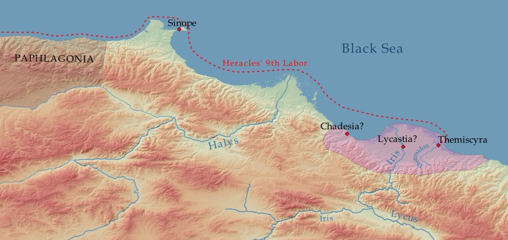
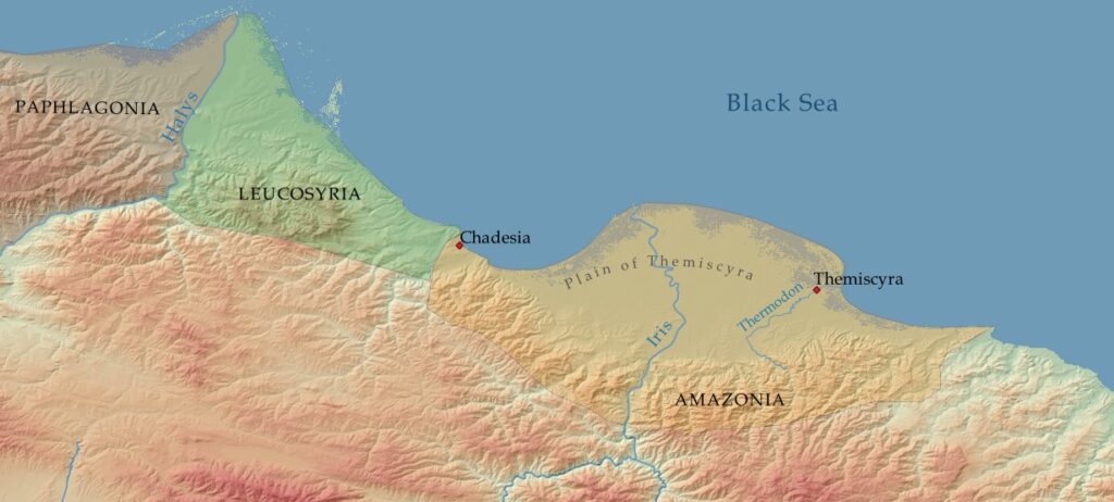
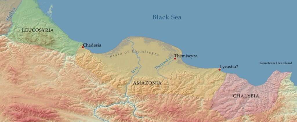
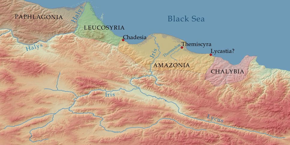
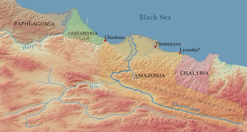
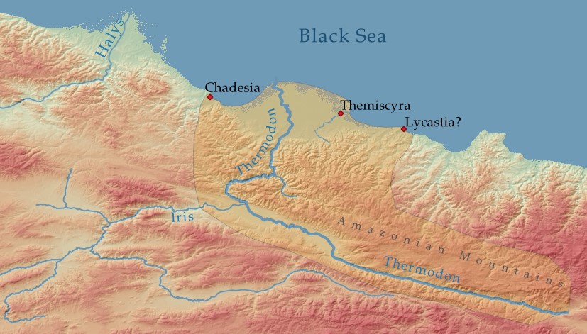
[3] Strabo 12.3.9

[4] Herodotus 1.6

[5] Pliny Natural History 6.3-4

[6] Pherecydes ap. Schol. ad Apollonius of Rhodes Argonautica 2.373, comp. ad 2.1001

[7] Apollonius of Rhodes Argonautica 2.1000

[8] Inscriptiones Graecae XIV, 1293, lines 93-104

[9] Apollonius of Rhodes Argonautica 2.955

[10] Apollonius of Rhodes Argonautica 2.970

[11] Strabo 12.3.15

[12] Strabo 11.14.8

[13] Pliny Natural History 6.3-4

[14] Dionysius Periegetes Periegesis 65

[15] Geographiae exposition compendiaria, I. 29 = Mullerus 1965, p. 501-2

[16] Pomponius Mela De situ orbis libri III 1.104-116

[17] Strabo 7.3.6

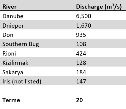
[18] Mikhailov, Vadim N., and Maria V. Mikhailova. “River mouths.” The Black Sea Environment (2007).

[19] Kilic, M. B., et al. “Investigation of discharge levels of dissolved inorganic nutrients from Yesilirmak River to the Black Sea.” Journal of Environmental Protection and Ecology 19.2 (2018).

[20] Ozturk, Fazlı, Halit Apaydin, and D. F. Walling. “Suspended sediment loads through flood events for streams of Sakarya River Basin.” Turk J Eng Environ Sci 25 (2001): p. 645.

[21] Pomponius Mela De situ orbis libri III 1.105

Leave a Comment

Your email address will not be published. Required fields are marked *